Make a donation
Gear up for your next adventure:
As an Amazon Associate, this site earns from qualifying purchases at no extra cost to you.
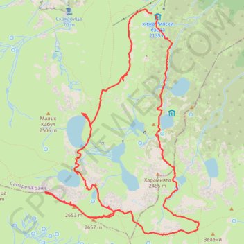
Rilska Jezera - Рилски Езера - Seven Rila Lakes
- Distance: 13.6 Km
- Elevation gain: 785 m
- Maximum elevation: 2,652 m
- Elevation loss: 792 m
- Minimum elevation: 2,053 m
- Moving time: 4 h 57 m
- Moving speed: 2.7 Km/h
- Maximum speed: 11.3 Km/h
- Total time: 7 h 43 m
- Global speed: 1.8 Km/h
Interactive trail map
Make a donation
Gear up for your next adventure:
As an Amazon Associate, this site earns from qualifying purchases at no extra cost to you.
Trail profile
- Distance: 13.6 Km
- Elevation gain: 785 m
- Maximum elevation: 2,652 m
- Elevation loss: 792 m
- Minimum elevation: 2,053 m
- Moving time: 4 h 57 m
- Moving speed: 2.7 Km/h
- Maximum speed: 11.3 Km/h
- Total time: 7 h 43 m
- Global speed: 1.8 Km/h
Make a donation
Gear up for your next adventure:
As an Amazon Associate, this site earns from qualifying purchases at no extra cost to you.
About this trail
Name: Rilska Jezera - Рилски Езера - Seven Rila Lakes trail, distance, elevation, map, profile, GPS track
Start: 15, Sapareva Bania, Kyustendil, Bulgaria (42.22021 23.32068)
End: Rilski Ezera, 15, Sapareva Bania, Kyustendil, Bulgaria (42.21994 23.32145)
Coordinates: 42.19220 23.30243 42.22076 23.32871
Make a donation
Gear up for your next adventure:
As an Amazon Associate, this site earns from qualifying purchases at no extra cost to you.
Other hiking, mountain biking, running and outdoor activity trails
Click on a trail to view its statistics, map and profile.
7 Rila lakes
Distance: 8.7 Km • Elevation gain: 576 m • Maximum elevation: 2,536 m
The Seven Rila Lakes Circuit (from/to top lift station (Rilski Ezera Hut)
Distance: 8.5 Km • Elevation gain: 596 m • Maximum elevation: 2,539 m