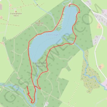
Castle Lake Walks
- Distance: 5.0 Km
- Elevation gain: 74 m
- Maximum elevation: 159 m
- Elevation loss: 77 m
- Minimum elevation: 133 m
- Moving time: 56 m 18 s
- Moving speed: 5.3 Km/h
- Maximum speed: 11.1 Km/h
- Total time: 1 h 8 m
- Global speed: 4.3 Km/h
Interactive trail map
Trail profile
- Distance: 5.0 Km
- Elevation gain: 74 m
- Maximum elevation: 159 m
- Elevation loss: 77 m
- Minimum elevation: 133 m
- Moving time: 56 m 18 s
- Moving speed: 5.3 Km/h
- Maximum speed: 11.1 Km/h
- Total time: 1 h 8 m
- Global speed: 4.3 Km/h
About this trail
Name: Castle Lake Walks trail, distance, elevation, map, profile, GPS track
Coordinates: 53.92573 -6.99108 53.93964 -6.97836
Other hiking, mountain biking, running and outdoor activity trails
Click on a trail to view its statistics, map and profile.
Castle Lake Walks
Afternoon Run
Distance: 16.3 Km • Elevation gain: 296 m • Maximum elevation: 179 m
Castle Lake Walks
Afternoon Run
Distance: 12.0 Km • Elevation gain: 189 m • Maximum elevation: 167 m