Make a donation
Gear up for your next adventure:
As an Amazon Associate, this site earns from qualifying purchases at no extra cost to you.
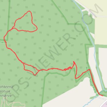
Rhododendron Cove Nature Preserve Trails
Loop hike in the Rhododendron Cove Nature Preserve and the Wahkeena Nature Preserve. #Hiking #Loop #Nature #Forest
- Distance: 3.3 Km
- Elevation gain: 122 m
- Maximum elevation: 320 m
- Elevation loss: 122 m
- Minimum elevation: 235 m
- Moving time: 59 m 29 s
- Moving speed: 3.3 Km/h
- Maximum speed: 11.2 Km/h
- Total time: 1 h 27 m
- Global speed: 2.3 Km/h
Interactive trail map
Make a donation
Gear up for your next adventure:
As an Amazon Associate, this site earns from qualifying purchases at no extra cost to you.
Trail profile
- Distance: 3.3 Km
- Elevation gain: 122 m
- Maximum elevation: 320 m
- Elevation loss: 122 m
- Minimum elevation: 235 m
- Moving time: 59 m 29 s
- Moving speed: 3.3 Km/h
- Maximum speed: 11.2 Km/h
- Total time: 1 h 27 m
- Global speed: 2.3 Km/h
Make a donation
Gear up for your next adventure:
As an Amazon Associate, this site earns from qualifying purchases at no extra cost to you.
About this trail
Name: Rhododendron Cove Nature Preserve Trails trail, distance, elevation, map, profile, GPS track
Coordinates: 39.63166 -82.56791 39.63735 -82.55925
Make a donation
Gear up for your next adventure:
As an Amazon Associate, this site earns from qualifying purchases at no extra cost to you.
Other hiking, mountain biking, running and outdoor activity trails
Click on a trail to view its statistics, map and profile.
Rhododendron Cove Trails
United States > Ohio > Fairfield County > Blue Valley Acres
Distance: 3.6 Km • Elevation gain: 118 m • Maximum elevation: 320 m