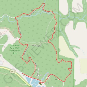
Afternoon hike at Schramm Park Nature Loop
- Distance: 3.9 Km
- Elevation gain: 76 m
- Maximum elevation: 365 m
- Elevation loss: 77 m
- Minimum elevation: 323 m
- Moving time: 56 m 31 s
- Moving speed: 4.1 Km/h
- Maximum speed: 12.6 Km/h
- Total time: 57 m 41 s
- Global speed: 4.1 Km/h
Interactive trail map
Trail profile
- Distance: 3.9 Km
- Elevation gain: 76 m
- Maximum elevation: 365 m
- Elevation loss: 77 m
- Minimum elevation: 323 m
- Moving time: 56 m 31 s
- Moving speed: 4.1 Km/h
- Maximum speed: 12.6 Km/h
- Total time: 57 m 41 s
- Global speed: 4.1 Km/h
About this trail
Name: Afternoon hike at Schramm Park Nature Loop trail, distance, elevation, map, profile, GPS track
Start: State Highway 31, Meadow, Sarpy County, Nebraska, 68059, United States (41.02151 -96.25011)
End: State Highway 31, Meadow, Sarpy County, Nebraska, 68059, United States (41.02155 -96.25036)
Coordinates: 41.02042 -96.25142 41.02946 -96.24299
Other hiking, mountain biking, running and outdoor activity trails
Click on a trail to view its statistics, map and profile.
Schramm Park State Recreation Area Loop via Meditation Trail, Suspension Bridge Trail, Backwoods Trail, NorthLoop Trail and South Loop Trail
United States > Nebraska > Sarpy County
This loop hike through Schramm Park State Recreation Area offers a delightful blend of natural beauty and recreational opportunities. Along the way, hikers can enjoy lush greenery, scenic views of the Platte River, and the unique experience of crossing a suspension bridge. Additionally, the area features…
Distance: 3.9 Km • Elevation gain: 73 m • Maximum elevation: 365 m