Make a donation
Gear up for your next adventure:
As an Amazon Associate, this site earns from qualifying purchases at no extra cost to you.
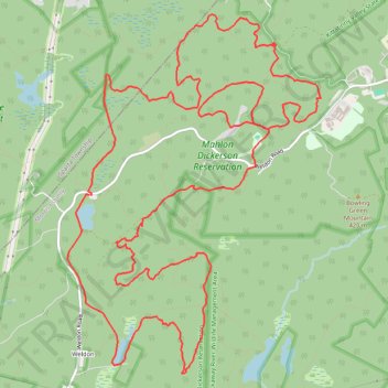
Mahlon Dickerson Reservation Loop
- Distance: 22.8 Km
- Elevation gain: 418 m
- Maximum elevation: 425 m
- Elevation loss: 418 m
- Minimum elevation: 300 m
- Moving time: 2 h 11 m
- Moving speed: 10.4 Km/h
- Maximum speed: 23.3 Km/h
- Total time: 2 h 26 m
- Global speed: 9.4 Km/h
Interactive trail map
Make a donation
Gear up for your next adventure:
As an Amazon Associate, this site earns from qualifying purchases at no extra cost to you.
Trail profile
- Distance: 22.8 Km
- Elevation gain: 418 m
- Maximum elevation: 425 m
- Elevation loss: 418 m
- Minimum elevation: 300 m
- Moving time: 2 h 11 m
- Moving speed: 10.4 Km/h
- Maximum speed: 23.3 Km/h
- Total time: 2 h 26 m
- Global speed: 9.4 Km/h
Make a donation
Gear up for your next adventure:
As an Amazon Associate, this site earns from qualifying purchases at no extra cost to you.
About this trail
Name: Mahlon Dickerson Reservation Loop trail, distance, elevation, map, profile, GPS track
Coordinates: 40.98945 -74.58962 41.02657 -74.55498
Make a donation
Gear up for your next adventure:
As an Amazon Associate, this site earns from qualifying purchases at no extra cost to you.
Other hiking, mountain biking, running and outdoor activity trails
Click on a trail to view its statistics, map and profile.
Weldon Brook Wildlife Management Area and Mahlon Dickerson Reservation loop trails
United States > New Jersey > Sussex County > Sparta Township
Distance: 22.4 Km • Elevation gain: 351 m • Maximum elevation: 410 m
Weldon Brook & Mahlon Dickerson
United States > New Jersey > Morris County > Jefferson Township
Distance: 29.9 Km • Elevation gain: 445 m • Maximum elevation: 425 m