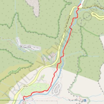
Pa'rus Trail
Interactive trail map
Trail profile
- Distance: 5.3 Km
- Elevation gain: 54 m
- Maximum elevation: 1,235 m
- Elevation loss: 54 m
- Minimum elevation: 1,199 m
- Moving time: 1 h 1 m
- Moving speed: 5.2 Km/h
- Maximum speed: 11.3 Km/h
- Total time: 1 h 6 m
- Global speed: 4.8 Km/h
About this trail
Name: Pa'rus Trail trail, distance, elevation, map, profile, GPS track
Start: Watchman Trail, Springdale, Washington County, Utah, 84767, United States (37.20132 -112.98658)
End: Watchman Trail, Springdale, Washington County, Utah, 84767, United States (37.20132 -112.98656)
Coordinates: 37.20132 -112.98682 37.21812 -112.97418
Other hiking, mountain biking, running and outdoor activity trails
Click on a trail to view its statistics, map and profile.
Watchman Trail and Overlook
United States > Utah > Washington County
From the Zion Canyon Visitor Center, the Watchman Trail follows the Virgin River past the Watchman Campground area before leaving the canyon floor. The route climbs through dry desert slopes, scattered shrubs and sandstone foothills toward the Watchman overlook loop. From the viewpoint, hikers look back over…
Distance: 5.0 Km • Elevation gain: 239 m • Maximum elevation: 1,357 m
Watchman Overlook Trail in Zion National Park
United States > Utah > Washington County
The Watchman Overlook Trail provides a moderate hike with rewarding views of iconic landmarks in the park. As you ascend from the Visitor Center, the trail offers vistas of the Virgin River and surrounding peaks like The Watchman, West Temple, and Bridge Mountain. The summit presents a dramatic overlook of…
Distance: 4.9 Km • Elevation gain: 288 m • Maximum elevation: 1,356 m
Watchman Trail in Zion National Park
United States > Utah > Washington County > Springdale
The Watchman Trail takes you on a gentle climb through stunning scenery, where you’ll find yourself surrounded by towering cliffs and vibrant landscapes. As you make your way to the outlook plateau, the views open up, revealing a breathtaking panorama of the Springdale area and the majestic Bridge Mountain.…
Distance: 6.0 Km • Elevation gain: 270 m • Maximum elevation: 1,358 m
Pa'rus Trail in Zion National Park
United States > Utah > Washington County > Springdale
The Pa'rus Trail in Zion National Park offers a leisurely walk along the Virgin River, providing panoramic views of the towering sandstone cliffs, including the iconic Watchman peak. As you stroll, you'll encounter lush meadows, cross charming footbridges, and have opportunities to observe local wildlife. The…
Distance: 5.3 Km • Elevation gain: 60 m • Maximum elevation: 1,237 m