Thank you for supporting this site ❤️
Make a donation
Make a donation
Gear up for your next adventure:
As an Amazon Associate, this site earns from qualifying purchases at no extra cost to you.
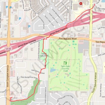
Ward Branch Greenway
- Distance: 3.2 Km
- Elevation gain: 13 m
- Maximum elevation: 386 m
- Elevation loss: 32 m
- Minimum elevation: 363 m
- Moving time: 13 m 59 s
- Moving speed: 13.6 Km/h
- Maximum speed: 27.5 Km/h
- Total time: 13 m 59 s
- Global speed: 13.6 Km/h
Interactive trail map
Thank you for supporting this site ❤️
Make a donation
Make a donation
Gear up for your next adventure:
As an Amazon Associate, this site earns from qualifying purchases at no extra cost to you.
Trail profile
- Distance: 3.2 Km
- Elevation gain: 13 m
- Maximum elevation: 386 m
- Elevation loss: 32 m
- Minimum elevation: 363 m
- Moving time: 13 m 59 s
- Moving speed: 13.6 Km/h
- Maximum speed: 27.5 Km/h
- Total time: 13 m 59 s
- Global speed: 13.6 Km/h
Thank you for supporting this site ❤️
Make a donation
Make a donation
Gear up for your next adventure:
As an Amazon Associate, this site earns from qualifying purchases at no extra cost to you.
About this trail
Name: Ward Branch Greenway trail, distance, elevation, map, profile, GPS track
Coordinates: 37.12727 -93.29598 37.14434 -93.27724
Thank you for supporting this site ❤️
Make a donation
Make a donation
Gear up for your next adventure:
As an Amazon Associate, this site earns from qualifying purchases at no extra cost to you.