Make a donation
Gear up for your next adventure:
As an Amazon Associate, this site earns from qualifying purchases at no extra cost to you.
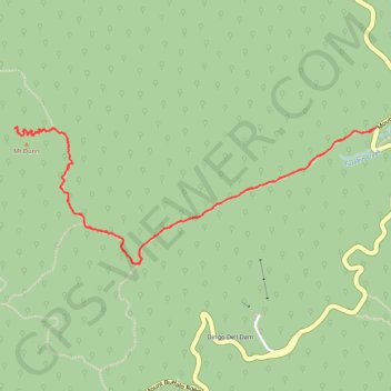
Mount Dunn
Hike to Mount Dunn via The Long Plain Walking Track in the Mount Buffalo National Park. #Hiking #Mountain #Nature #Forest #Park
- Distance: 7.4 Km
- Elevation gain: 256 m
- Maximum elevation: 1,487 m
- Elevation loss: 256 m
- Minimum elevation: 1,298 m
- Moving time: 1 h 20 m
- Moving speed: 5.5 Km/h
- Maximum speed: 13.1 Km/h
- Total time: 1 h 28 m
- Global speed: 5.0 Km/h
Interactive trail map
Make a donation
Gear up for your next adventure:
As an Amazon Associate, this site earns from qualifying purchases at no extra cost to you.
Trail profile
- Distance: 7.4 Km
- Elevation gain: 256 m
- Maximum elevation: 1,487 m
- Elevation loss: 256 m
- Minimum elevation: 1,298 m
- Moving time: 1 h 20 m
- Moving speed: 5.5 Km/h
- Maximum speed: 13.1 Km/h
- Total time: 1 h 28 m
- Global speed: 5.0 Km/h
Make a donation
Gear up for your next adventure:
As an Amazon Associate, this site earns from qualifying purchases at no extra cost to you.
About this trail
Name: Mount Dunn trail, distance, elevation, map, profile, GPS track
Start: The Long Plain Walking Track, Mount Buffalo, Alpine Shire, Victoria, Australia (-36.73518 146.80482)
End: The Long Plain Walking Track, Mount Buffalo, Alpine Shire, Victoria, Australia (-36.73503 146.80504)
Coordinates: -36.74260 146.78029 -36.73501 146.80504
Make a donation
Gear up for your next adventure:
As an Amazon Associate, this site earns from qualifying purchases at no extra cost to you.
Other hiking, mountain biking, running and outdoor activity trails
Click on a trail to view its statistics, map and profile.
Macks Point Track, Mollisons Galleries and Eagle Point Loop
Distance: 21.4 Km • Elevation gain: 751 m • Maximum elevation: 1,514 m