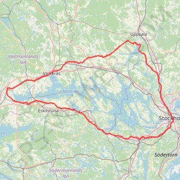
Lake-Mälaren
- Distance: 336.3 Km
- Elevation gain: 2,518 m
- Maximum elevation: 74 m
- Elevation loss: 2,519 m
- Minimum elevation: 0 m
Interactive trail map
Trail profile
- Distance: 336.3 Km
- Elevation gain: 2,518 m
- Maximum elevation: 74 m
- Elevation loss: 2,519 m
- Minimum elevation: 0 m
About this trail
Name: Lake-Mälaren trail, distance, elevation, map, profile, GPS track
Coordinates: 59.18478 15.98465 59.81416 18.08018