Make a donation
Gear up for your next adventure:
As an Amazon Associate, this site earns from qualifying purchases at no extra cost to you.
PR1
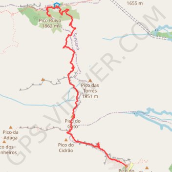
- Distance: 5.7 Km
- Elevation gain: 788 m
- Maximum elevation: 1,836 m
- Elevation loss: 759 m
- Minimum elevation: 1,515 m
Interactive trail map
Make a donation
Gear up for your next adventure:
As an Amazon Associate, this site earns from qualifying purchases at no extra cost to you.
Trail profile
- Distance: 5.7 Km
- Elevation gain: 788 m
- Maximum elevation: 1,836 m
- Elevation loss: 759 m
- Minimum elevation: 1,515 m
Make a donation
Gear up for your next adventure:
As an Amazon Associate, this site earns from qualifying purchases at no extra cost to you.
About this trail
Name: PR1 trail, distance, elevation, map, profile, GPS track
End: Vereda da Encumeada, Faial, Santana, Madeira, 9030-311, Portugal (32.75892 -16.94278)
Coordinates: 32.73555 -16.94340 32.76028 -16.92881
Make a donation
Gear up for your next adventure:
As an Amazon Associate, this site earns from qualifying purchases at no extra cost to you.
Other hiking, mountain biking, running and outdoor activity trails
Click on a trail to view its statistics, map and profile.
Santana - Le pico Ruivo depuis Achada do Teixeira
Distance: 6.3 Km • Elevation gain: 503 m • Maximum elevation: 1,837 m
MIUT2020_115_training
Distance: 119.5 Km • Elevation gain: 10,113 m • Maximum elevation: 1,797 m
MIUT2023_115_training
Distance: 112.2 Km • Elevation gain: 9,384 m • Maximum elevation: 1,797 m
MIUT2020_115_training
Distance: 119.5 Km • Elevation gain: 10,113 m • Maximum elevation: 1,797 m
Make a donation
Gear up for your next adventure:
As an Amazon Associate, this site earns from qualifying purchases at no extra cost to you.
Passeio aniversario nsr
Route created on plotaroute.com
Distance: 59.3 Km • Elevation gain: 3,095 m • Maximum elevation: 1,089 m