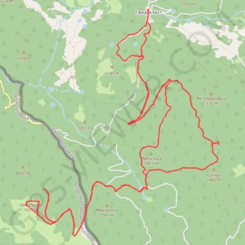
Predov Krst - Veliki Stolac - Vidikovac Sjenič - Predov Krst
- Distance: 22.3 Km
- Elevation gain: 804 m
- Maximum elevation: 1,664 m
- Elevation loss: 804 m
- Minimum elevation: 1,068 m
- Moving time: 5 h 15 m
- Moving speed: 4.2 Km/h
- Maximum speed: 8.6 Km/h
- Total time: 8 h 10 m
- Global speed: 2.7 Km/h
Interactive trail map
Trail profile
- Distance: 22.3 Km
- Elevation gain: 804 m
- Maximum elevation: 1,664 m
- Elevation loss: 804 m
- Minimum elevation: 1,068 m
- Moving time: 5 h 15 m
- Moving speed: 4.2 Km/h
- Maximum speed: 8.6 Km/h
- Total time: 8 h 10 m
- Global speed: 2.7 Km/h
About this trail
Name: Predov Krst - Veliki Stolac - Vidikovac Sjenič - Predov Krst trail, distance, elevation, map, profile, GPS track
Coordinates: 43.90864 19.28455 43.94199 19.32408
Other hiking, mountain biking, running and outdoor activity trails
Click on a trail to view its statistics, map and profile.
2022_Yu
Slovenia > Ajdovščina > Žapuže
Distance: 2,457.3 Km • Elevation gain: 32,048 m • Maximum elevation: 1,950 m
Predov Krst-VidikovacBilješka Stena-Vidikovac Drlije-Jagošti...
Serbia > Central Serbia > Zlatibor Administrative District > Bajina Basta Municipality > Rastiste > Predov Krst
Distance: 33.9 Km • Elevation gain: 1,374 m • Maximum elevation: 1,341 m