Lake Ingalls via Ingalls Way Trail and Ingalls Pass in Alpine Lakes Wilderness
The hike to Lake Ingalls offers an incredible adventure through the Alpine Lakes Wilderness, with expansive views of rugged peaks and serene alpine waters. From the trailhead, you will experience a steady climb, surrounded by dense forests and stunning vistas of the Esmerelda Peaks and Headlight Basin. Upon reaching the lake, you're greeted with jagged mountains towering over the sapphire-blue waters of Lake Ingalls, with Mount Stuart looming in the background, making for a truly unforgettable experience. #Hiking #Mountain #Forest #Nature #Lake
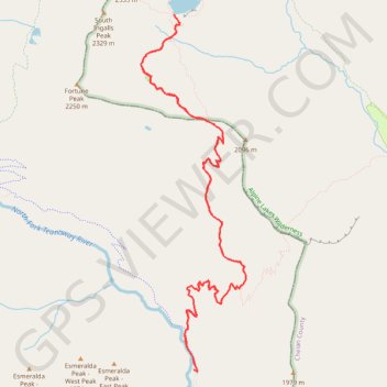
- Distance: 14.1 Km
- Elevation gain: 872 m
- Maximum elevation: 1,986 m
- Elevation loss: 875 m
- Minimum elevation: 1,301 m
Interactive trail map
Trail profile
- Distance: 14.1 Km
- Elevation gain: 872 m
- Maximum elevation: 1,986 m
- Elevation loss: 875 m
- Minimum elevation: 1,301 m
About this trail
Name: Lake Ingalls via Ingalls Way Trail and Ingalls Pass in Alpine Lakes Wilderness trail, distance, elevation, map, profile, GPS track
Start: Esmeralda Basin Trail #1394, Kittitas County, Washington, United States (47.43697 -120.93690)
Coordinates: 47.43669 -120.94434 47.46897 -120.93037
Other hiking, mountain biking, running and outdoor activity trails
Click on a trail to view its statistics, map and profile.
Northern part of the Pacific Crest Trail (PCT)
United States > Oregon > Klamath County
Hike on the Pacific Crest National Scenic Trail from Crater Lake to Canada Border through Oregon and Washington along the Sierra Nevada and Cascade mountain ranges. #Hiking #Mountain #SierraNevada #Cascade #Nature #Forest #Park #PCT
Distance: 1,198.3 Km • Elevation gain: 44,308 m • Maximum elevation: 2,307 m