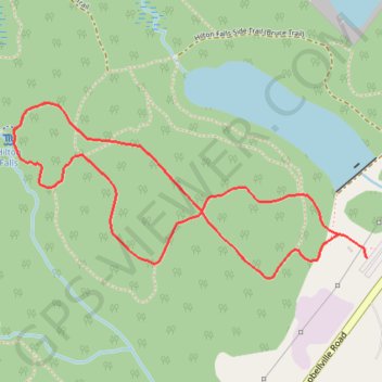
Hilton Falls Trail
Hilton Falls Conservation Area. #Hiking #MTB #Snowshoeing #Ski #Loop #HiltonFalls
- Distance: 4.1 Km
- Elevation gain: 60 m
- Maximum elevation: 309 m
- Elevation loss: 60 m
- Minimum elevation: 272 m
Interactive trail map
Trail profile
- Distance: 4.1 Km
- Elevation gain: 60 m
- Maximum elevation: 309 m
- Elevation loss: 60 m
- Minimum elevation: 272 m
About this trail
Name: Hilton Falls Trail trail, distance, elevation, map, profile, GPS track
Coordinates: 43.50492 -79.97886 43.51098 -79.96201
Topography: Halton Region topographic map, elevation, terrain
Other hiking, mountain biking, running and outdoor activity trails
Click on a trail to view its statistics, map and profile.
Ontario country roads
Distance: 150.4 Km • Elevation gain: 1,137 m • Maximum elevation: 497 m