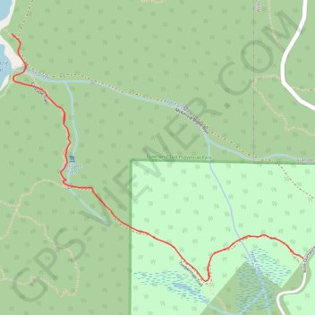
McKenzie Bight - Cascade Falls
Gowlland Tod Provincial Park. #Hiking #GowllandTod
- Distance: 3.4 Km
- Elevation gain: 160 m
- Maximum elevation: 150 m
- Elevation loss: 160 m
- Minimum elevation: 11 m
Interactive trail map
Trail profile
- Distance: 3.4 Km
- Elevation gain: 160 m
- Maximum elevation: 150 m
- Elevation loss: 160 m
- Minimum elevation: 11 m
About this trail
Name: McKenzie Bight - Cascade Falls trail, distance, elevation, map, profile, GPS track
Coordinates: 48.54793 -123.50509 48.55519 -123.49217
Topography: Capital Regional District topographic map, elevation, terrain
Other hiking, mountain biking, running and outdoor activity trails
Click on a trail to view its statistics, map and profile.
Mount Work - Mount Stewart - Thetis Lake
Canada > British Columbia > Capital Regional District > Highlands
Distance: 20.2 Km • Elevation gain: 697 m • Maximum elevation: 436 m
BBF loop to the Skydeck in Nanaimo
Canada > British Columbia > Cowichan Valley Regional District > Area A (Mill Bay / Malahat) > Mill Bay
BBF loop to the Skydeck
Distance: 323.5 Km • Elevation gain: 6,222 m • Maximum elevation: 706 m