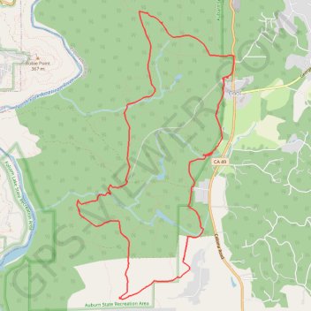
Import a GPX file

Olmstead Loop Trail

Mountain Bike loop in Auburn State Recreation Area. #MTB #Loop #Forest #Nature

  • Distance: 14.9 Km
  • Elevation gain: 308 m
  • Maximum elevation: 496 m
  • Elevation loss: 308 m
  • Minimum elevation: 381 m
  • Moving time: 1 h 32 m
  • Moving speed: 9.7 Km/h
  • Maximum speed: 29.4 Km/h
  • Total time: 1 h 55 m
  • Global speed: 7.8 Km/h

Interactive trail map

Trail profile

  • Distance: 14.9 Km
  • Elevation gain: 308 m
  • Maximum elevation: 496 m
  • Elevation loss: 308 m
  • Minimum elevation: 381 m
  • Moving time: 1 h 32 m
  • Moving speed: 9.7 Km/h
  • Maximum speed: 29.4 Km/h
  • Total time: 1 h 55 m
  • Global speed: 7.8 Km/h

About this trail

Name: Olmstead Loop Trail trail, distance, elevation, map, profile, GPS track

Start: Olmstead Loop Trail, Cool, El Dorado County, California, 95614, United States (38.88923 -121.01723)

End: Olmstead Loop Trail, Cool, El Dorado County, California, 95614, United States (38.88925 -121.01737)

Coordinates: 38.85715 -121.04513 38.89879 -121.01597

Gear up for your next adventure:

💧Hydration Bladder - Hands-free hydration solution for long treks
🥫Freeze-Dried Meals - Lightweight, high-calorie nutrition for multi-day treks
🥾Trekking Boots - Durable boots for long-distance trekking
🥾Hiking Boots - Sturdy boots providing ankle support and traction on rugged trails
Lightweight Camping Tent - Portable shelter optimized for Canadian backcountry camping

As an Amazon Associate, this site earns from qualifying purchases at no extra cost to you.