Import a GPX file

Ganondagan State Historic Site: trail west from main building to Fort Hill

  • Distance: 5.1 Km
  • Elevation gain: 131 m
  • Maximum elevation: 257 m
  • Elevation loss: 113 m
  • Minimum elevation: 199 m
  • Moving time: 1 h 32 m
  • Moving speed: 3.3 Km/h
  • Maximum speed: 9.7 Km/h
  • Total time: 1 h 47 m
  • Global speed: 2.8 Km/h

Interactive trail map

Trail profile

  • Distance: 5.1 Km
  • Elevation gain: 131 m
  • Maximum elevation: 257 m
  • Elevation loss: 113 m
  • Minimum elevation: 199 m
  • Moving time: 1 h 32 m
  • Moving speed: 3.3 Km/h
  • Maximum speed: 9.7 Km/h
  • Total time: 1 h 47 m
  • Global speed: 2.8 Km/h

About this trail
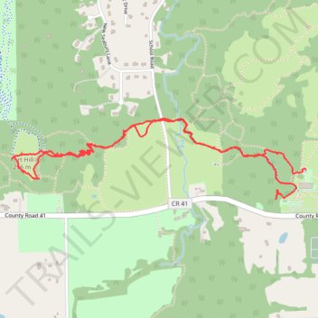
Name: Ganondagan State Historic Site: trail west from main building to Fort Hill trail, distance, elevation, map, profile, GPS track

Start: 7071, County Road 41, Boughton Hill, Town of Victor, Ontario County, New York, 14564, United States (42.96187 -77.41700)

End: Bark Longhouse, Trail of Peace, Boughton Hill, Town of Victor, Ontario County, New York, 14564, United States (42.96342 -77.41487)

Coordinates: 42.96187 -77.43537 42.96598 -77.41487

Gear up for your next adventure:

🥾Mountain Hiking Boots - High-traction boots for rocky terrain
🔦LED Flashlight - Powerful and long-lasting flashlight for camping and emergencies
🧊Portable Cooler - Keep food and drinks cold during outdoor adventures
🪑Ultralight Camping Stool - Compact seating for rest stops during long hikes
💡LED Camping Lantern - Illuminate your campsite with long-lasting lanterns

As an Amazon Associate, this site earns from qualifying purchases at no extra cost to you.