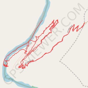
Honaker trail from San Juan River
- Distance: 9.7 Km
- Elevation gain: 1,007 m
- Maximum elevation: 1,577 m
- Elevation loss: 1,090 m
- Minimum elevation: 1,205 m
- Moving time: 2 h 29 m
- Moving speed: 3.9 Km/h
- Maximum speed: 26.9 Km/h
- Total time: 3 h 40 m
- Global speed: 2.6 Km/h
Interactive trail map
Trail profile
- Distance: 9.7 Km
- Elevation gain: 1,007 m
- Maximum elevation: 1,577 m
- Elevation loss: 1,090 m
- Minimum elevation: 1,205 m
- Moving time: 2 h 29 m
- Moving speed: 3.9 Km/h
- Maximum speed: 26.9 Km/h
- Total time: 3 h 40 m
- Global speed: 2.6 Km/h
About this trail
Name: Honaker trail from San Juan River trail, distance, elevation, map, profile, GPS track
Start: Honaker Trail, San Juan County, Utah, United States (37.18535 -109.96130)
End: Honaker Trail, San Juan County, Utah, United States (37.18880 -109.95914)
Coordinates: 37.18360 -109.96442 37.18886 -109.95346