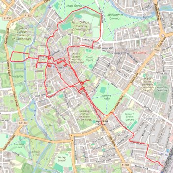
Cambridge
- Distance: 9.7 Km
- Elevation gain: 37 m
- Maximum elevation: 21 m
- Elevation loss: 36 m
- Minimum elevation: 9 m
- Moving time: 2 h 58 m
- Moving speed: 3.2 Km/h
- Maximum speed: 9.1 Km/h
- Total time: 5 h 17 m
- Global speed: 1.8 Km/h
Interactive trail map
Trail profile
- Distance: 9.7 Km
- Elevation gain: 37 m
- Maximum elevation: 21 m
- Elevation loss: 36 m
- Minimum elevation: 9 m
- Moving time: 2 h 58 m
- Moving speed: 3.2 Km/h
- Maximum speed: 9.1 Km/h
- Total time: 5 h 17 m
- Global speed: 1.8 Km/h
About this trail
Name: Cambridge trail, distance, elevation, map, profile, GPS track
Coordinates: 52.19475 0.11157 52.21154 0.13773
Other hiking, mountain biking, running and outdoor activity trails
Click on a trail to view its statistics, map and profile.
Gog Coffee Loop Ride
United Kingdom > England > Cambridgeshire > Cambridge
Distance: 38.5 Km • Elevation gain: 191 m • Maximum elevation: 70 m