Thank you for supporting this site ❤️
Make a donation
Make a donation
Gear up for your next adventure:
As an Amazon Associate, this site earns from qualifying purchases at no extra cost to you.
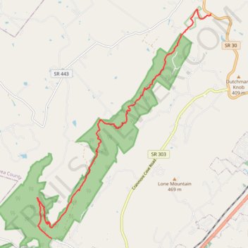
Cumberland Trail Graysville Mountain Trail
- Distance: 15.1 Km
- Elevation gain: 695 m
- Maximum elevation: 545 m
- Elevation loss: 466 m
- Minimum elevation: 268 m
- Moving time: 3 h 49 m
- Moving speed: 3.9 Km/h
- Maximum speed: 8.1 Km/h
- Total time: 4 h 55 m
- Global speed: 3.1 Km/h
Interactive trail map
Thank you for supporting this site ❤️
Make a donation
Make a donation
Gear up for your next adventure:
As an Amazon Associate, this site earns from qualifying purchases at no extra cost to you.
Trail profile
- Distance: 15.1 Km
- Elevation gain: 695 m
- Maximum elevation: 545 m
- Elevation loss: 466 m
- Minimum elevation: 268 m
- Moving time: 3 h 49 m
- Moving speed: 3.9 Km/h
- Maximum speed: 8.1 Km/h
- Total time: 4 h 55 m
- Global speed: 3.1 Km/h
Thank you for supporting this site ❤️
Make a donation
Make a donation
Gear up for your next adventure:
As an Amazon Associate, this site earns from qualifying purchases at no extra cost to you.
About this trail
Name: Cumberland Trail Graysville Mountain Trail trail, distance, elevation, map, profile, GPS track
Coordinates: 35.45926 -85.11037 35.52722 -85.04704
Thank you for supporting this site ❤️
Make a donation
Make a donation
Gear up for your next adventure:
As an Amazon Associate, this site earns from qualifying purchases at no extra cost to you.