Make a donation
Gear up for your next adventure:
As an Amazon Associate, this site earns from qualifying purchases at no extra cost to you.
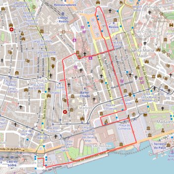
01_BaixaChiado
- Distance: 3.3 Km
- Elevation gain: 83 m
- Maximum elevation: 58 m
- Elevation loss: 36 m
- Minimum elevation: -4 m
Interactive trail map
Make a donation
Gear up for your next adventure:
As an Amazon Associate, this site earns from qualifying purchases at no extra cost to you.
Trail profile
- Distance: 3.3 Km
- Elevation gain: 83 m
- Maximum elevation: 58 m
- Elevation loss: 36 m
- Minimum elevation: -4 m
Make a donation
Gear up for your next adventure:
As an Amazon Associate, this site earns from qualifying purchases at no extra cost to you.
About this trail
Name: 01_BaixaChiado trail, distance, elevation, map, profile, GPS track
Start: Jardim Roque Gameiro, Cais do Sodré, Misericórdia, Lisbon, 1249-289, Portugal (38.70591 -9.14379)
Coordinates: 38.70538 -9.14379 38.71501 -9.13618
Make a donation
Gear up for your next adventure:
As an Amazon Associate, this site earns from qualifying purchases at no extra cost to you.
Other hiking, mountain biking, running and outdoor activity trails
Click on a trail to view its statistics, map and profile.
EuroVelo 1 (Por
Portugal > Viana do Castelo > Caminha > Terreiro
Distance: 1,156.4 Km • Elevation gain: 10,823 m • Maximum elevation: 254 m