Make a donation
Gear up for your next adventure:
As an Amazon Associate, this site earns from qualifying purchases at no extra cost to you.
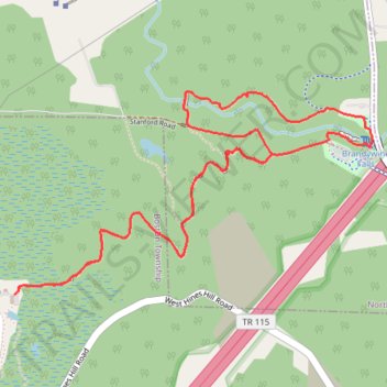
Brandywine Falls and Gorge Loop via Stanford Trail in Cuyahoga Valley National Park
The Brandywine Gorge Loop via the Stanford Trail offers hikers a journey through lush forests, leading to the impressive Brandywine Falls, where water cascades over layered sandstone cliffs. As the trail descends into the gorge, visitors are treated to views of Brandywine Creek, surrounded by moss-covered rocks and towering hemlock trees. The path also passes near the historic Inn at Brandywine Falls, adding a touch of cultural heritage to the natural beauty. #Hiking #Waterfall #Forest #Nature #Gorge #Loop
- Distance: 5.9 Km
- Elevation gain: 151 m
- Maximum elevation: 261 m
- Elevation loss: 151 m
- Minimum elevation: 203 m
- Moving time: 1 h 43 m
- Moving speed: 3.4 Km/h
- Maximum speed: 9.2 Km/h
- Total time: 1 h 52 m
- Global speed: 3.2 Km/h
Interactive trail map
Make a donation
Gear up for your next adventure:
As an Amazon Associate, this site earns from qualifying purchases at no extra cost to you.
Trail profile
- Distance: 5.9 Km
- Elevation gain: 151 m
- Maximum elevation: 261 m
- Elevation loss: 151 m
- Minimum elevation: 203 m
- Moving time: 1 h 43 m
- Moving speed: 3.4 Km/h
- Maximum speed: 9.2 Km/h
- Total time: 1 h 52 m
- Global speed: 3.2 Km/h
Make a donation
Gear up for your next adventure:
As an Amazon Associate, this site earns from qualifying purchases at no extra cost to you.
About this trail
Name: Brandywine Falls and Gorge Loop via Stanford Trail in Cuyahoga Valley National Park trail, distance, elevation, map, profile, GPS track
Start: Stanford Trail, Boston Township, Summit County, Ohio, 44264, United States (41.27105 -81.55596)
End: Stanford Trail, Boston Township, Summit County, Ohio, 44264, United States (41.27106 -81.55595)
Coordinates: 41.27105 -81.55596 41.27867 -81.53811
Make a donation
Gear up for your next adventure:
As an Amazon Associate, this site earns from qualifying purchases at no extra cost to you.
Other hiking, mountain biking, running and outdoor activity trails
Click on a trail to view its statistics, map and profile.
Brandywine Gorge Loop Trail in Cuyahoga Valley National Park
United States > Ohio > Summit County
The Brandywine Gorge Loop Trail offers a delightful hiking experience, highlighted by scenic views of Brandywine Falls and the surrounding gorge. The trail features a mix of boardwalks and dirt paths that lead through lush greenery, past intriguing rock formations, and alongside the serene waters of Brandywine…
Distance: 2.4 Km • Elevation gain: 55 m • Maximum elevation: 261 m
Brandywine Falls and Brandywine Gorge Loop from Stanford House in Cuyahoga Valley National Park
United States > Ohio > Summit County
The Brandywine Falls and Brandywine Gorge Loop hike offers a delightful experience, showcasing the stunning Brandywine Falls as the centerpiece of the route. Along the trail, hikers can enjoy scenic views of the gorge and the surrounding lush forests, making it particularly beautiful during the spring and…
Distance: 5.8 Km • Elevation gain: 129 m • Maximum elevation: 261 m