Alberta Falls Trail
Hike to Alberta Falls via Glacier Gorge Trail in Rocky Mountain National Park #Hiking #Mountain #Forest #Waterfall
- Distance: 2.7 Km
- Elevation gain: 96 m
- Maximum elevation: 2,879 m
- Elevation loss: 96 m
- Minimum elevation: 2,795 m
- Moving time: 39 m
- Moving speed: 4.2 Km/h
- Maximum speed: 6.0 Km/h
- Total time: 1 h 17 s
- Global speed: 2.7 Km/h
Interactive trail map
Trail profile
- Distance: 2.7 Km
- Elevation gain: 96 m
- Maximum elevation: 2,879 m
- Elevation loss: 96 m
- Minimum elevation: 2,795 m
- Moving time: 39 m
- Moving speed: 4.2 Km/h
- Maximum speed: 6.0 Km/h
- Total time: 1 h 17 s
- Global speed: 2.7 Km/h
About this trail
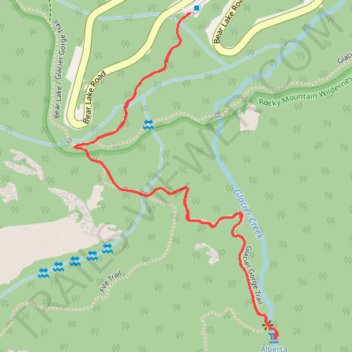
Name: Alberta Falls Trail trail, distance, elevation, map, profile, GPS track
Start: Glacier Gorge Trail, Larimer County, Colorado, United States (40.31040 -105.64029)
End: Glacier Gorge Trail, Larimer County, Colorado, United States (40.31040 -105.64029)
Coordinates: 40.30365 -105.64346 40.31040 -105.63792
Other hiking, mountain biking, running and outdoor activity trails
Click on a trail to view its statistics, map and profile.
Bear Lake to Timberline Falls Loop
United States > Colorado > Larimer County
Starting at Bear Lake in Rocky Mountain National Park’s Bear Lake Road Corridor, this loop briefly follows the shore before climbing onto the Emerald Lake Trail toward Nymph Lake and Dream Lake. The traced route then leaves the direct Emerald Lake approach, turns toward Chaos Creek, and reaches the rocky…
Distance: 15.6 Km • Elevation gain: 712 m • Maximum elevation: 3,281 m
Sky Pond via Glacier Gorge Trail in Rocky Mountain National Park
United States > Colorado > Larimer County
The hike to Sky Pond is a wonderful way to experience the stunning landscapes of Rocky Mountain National Park. Along the route, you'll enjoy scenic highlights like Alberta Falls and The Loch, where the tranquil waters and surrounding views offer perfect spots to relax. The final stretch involves a bit of rock…
Distance: 15.6 Km • Elevation gain: 610 m • Maximum elevation: 3,317 m
Alberta Falls via Glacier Gorge Trail in Rocky Mountain National Park
United States > Colorado > Larimer County
The hike to Alberta Falls via the Glacier Gorge Trail in Rocky Mountain National Park offers a family-friendly adventure through vibrant aspen groves and towering pine forests. Along the well-marked path, hikers can enjoy the tranquil sounds of Glacier Creek and may encounter local wildlife amidst the stunning…
Distance: 2.7 Km • Elevation gain: 87 m • Maximum elevation: 2,874 m
Sky Pond via Glacier Gorge Trail and Sky Pond Trail in Rocky Mountain National Park
United States > Colorado > Larimer County
The hike to Sky Pond in Rocky Mountain National Park offers a variety of scenic wonders. As you trek along the trail, you'll pass through forests and meadows, with Alberta Falls providing an early highlight. The trail continues with views of Glacier Creek and The Loch, an alpine lake framed by towering peaks…
Distance: 13.8 Km • Elevation gain: 600 m • Maximum elevation: 3,317 m
Nymph Lake, Dream Lake, Emerald Lake and Bear Lake in Rocky Mountain National Park
United States > Colorado > Larimer County
The hike connecting Nymph Lake, Dream Lake, Emerald Lake, and Bear Lake in Rocky Mountain National Park offers a rewarding experience through some of the park's most scenic spots. Starting at Bear Lake, hikers will pass through lush forests and along cascading streams, with views of impressive peaks like…
Distance: 7.8 Km • Elevation gain: 216 m • Maximum elevation: 3,094 m