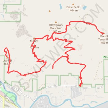
Track (8/12/23, 7:47:57AM)
- Distance: 57.9 Km
- Elevation gain: 3,713 m
- Maximum elevation: 1,404 m
- Elevation loss: 3,713 m
- Minimum elevation: 236 m
- Moving time: 10 h 51 s
- Moving speed: 5.8 Km/h
- Maximum speed: 40.2 Km/h
- Total time: 10 h 7 m
- Global speed: 5.7 Km/h
Interactive trail map
Trail profile
- Distance: 57.9 Km
- Elevation gain: 3,713 m
- Maximum elevation: 1,404 m
- Elevation loss: 3,713 m
- Minimum elevation: 236 m
- Moving time: 10 h 51 s
- Moving speed: 5.8 Km/h
- Maximum speed: 40.2 Km/h
- Total time: 10 h 7 m
- Global speed: 5.7 Km/h
About this trail
Name: Track (8/12/23, 7:47:57AM) trail, distance, elevation, map, profile, GPS track
Start: Mount Teneriffe Trail, King County, Washington, United States (47.48629 -121.71001)
End: Mount Teneriffe Trail, King County, Washington, United States (47.48647 -121.70994)
Coordinates: 47.48629 -121.75797 47.51410 -121.69515
Other hiking, mountain biking, running and outdoor activity trails
Click on a trail to view its statistics, map and profile.
Teneriffe Falls Trail
United States > Washington > King County
Starting at the Mount Teneriffe trailhead, this hike follows the forested Mount Teneriffe Trail through the Mount Si Natural Resources Conservation Area, with occasional openings toward the Snoqualmie Valley and nearby peaks. The route then turns onto the Teneriffe Falls Trail, climbing more steeply through…
Distance: 9.5 Km • Elevation gain: 555 m • Maximum elevation: 760 m
Mount Teneriffe via Teneriffe Falls Trail and Kamikaze Trail
United States > Washington > King County
The hike to Mount Teneriffe offers a combination of natural beauty and physical challenge in Mount Si Natural Resources Conservation Area. The trail begins with a serene forested path leading to the striking Teneriffe Falls, which are especially impressive during the spring. Continuing upwards, the…
Distance: 12.1 Km • Elevation gain: 1,176 m • Maximum elevation: 1,396 m
Mount Si
United States > Washington > King County
From the Mount Si Trailhead, the route enters the forested lower slopes of the Mount Si Natural Resources Conservation Area and follows the main Mount Si Trail into a steady switchbacking ascent above North Bend. After the first wooded climb, it passes through Snag Flat, an old-growth forest section, then…
Distance: 12.3 Km • Elevation gain: 1,043 m • Maximum elevation: 1,229 m
Teneriffe Falls Trail in Mount Si Natural Resources Conservation Area
United States > Washington > King County
The Teneriffe Falls Trail in Washington's Mount Si Natural Resources Conservation Area offers hikers a journey through lush forests, crossing several streams via charming bridges. As you ascend, the trail provides glimpses of the surrounding valleys and mountains, with the possibility of spotting mountain…
Distance: 9.1 Km • Elevation gain: 513 m • Maximum elevation: 757 m
Mount Si Trail in Mount Si Natural Resources Conservation Area
United States > Washington > King County
The Mount Si Trail offers an exhilarating journey through a vibrant forest, leading you to breathtaking panoramic views of the surrounding Cascade Mountains, the picturesque Snoqualmie Valley and Mount Rainier emerging in the distance. With each step, you’re embraced by nature’s beauty, from the soothing…
Distance: 12.9 Km • Elevation gain: 1,039 m • Maximum elevation: 1,228 m
Mount Si Trail in Mount Si Natural Resources Conservation Area
United States > Washington > King County
Mount Si Trail, one of the most iconic hikes in the Pacific Northwest, offers hikers a steady ascent through dense forests and occasional open areas revealing breathtaking vistas. As you climb, you'll pass through old-growth sections, where towering trees and lush foliage set the stage for stunning views of…
Distance: 12.2 Km • Elevation gain: 1,018 m • Maximum elevation: 1,193 m
Mount Si Trail and Mount Teneriffe Trail Loop
United States > Washington > King County
The loop hike via Mount Si and Mount Teneriffe Trails provides an exceptional experience in the Mount Si Natural Resources Conservation Area. The route offers a mix of dense, lush forests and sweeping vistas, including views of Mount Rainier, Rattlesnake Ridge, and the surrounding Cascades. Hikers will…
Distance: 14.0 Km • Elevation gain: 1,014 m • Maximum elevation: 1,205 m
Northern part of the Pacific Crest Trail (PCT)
United States > Oregon > Klamath County
Hike on the Pacific Crest National Scenic Trail from Crater Lake to Canada Border through Oregon and Washington along the Sierra Nevada and Cascade mountain ranges. #Hiking #Mountain #SierraNevada #Cascade #Nature #Forest #Park #PCT
Distance: 1,198.3 Km • Elevation gain: 44,308 m • Maximum elevation: 2,307 m
Old Mount Si Trail
United States > Washington > King County > North Bend
Distance: 13.3 Km • Elevation gain: 1,085 m • Maximum elevation: 1,153 m