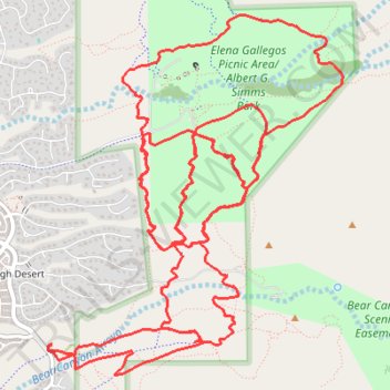
Elena Gallegos / Albert G. Simms Park trails
- Distance: 22.1 Km
- Elevation gain: 404 m
- Maximum elevation: 2,054 m
- Elevation loss: 404 m
- Minimum elevation: 1,888 m
- Moving time: 2 h 9 m
- Moving speed: 10.2 Km/h
- Maximum speed: 31.6 Km/h
- Total time: 2 h 25 m
- Global speed: 9.1 Km/h
Interactive trail map
Trail profile
- Distance: 22.1 Km
- Elevation gain: 404 m
- Maximum elevation: 2,054 m
- Elevation loss: 404 m
- Minimum elevation: 1,888 m
- Moving time: 2 h 9 m
- Moving speed: 10.2 Km/h
- Maximum speed: 31.6 Km/h
- Total time: 2 h 25 m
- Global speed: 9.1 Km/h
About this trail
Name: Elena Gallegos / Albert G. Simms Park trails trail, distance, elevation, map, profile, GPS track
Coordinates: 35.14412 -106.48286 35.17023 -106.45669