Make a donation
Gear up for your next adventure:
As an Amazon Associate, this site earns from qualifying purchases at no extra cost to you.
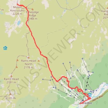
Mount Kosciuszko
- Distance: 20.0 Km
- Elevation gain: 921 m
- Maximum elevation: 2,226 m
- Elevation loss: 920 m
- Minimum elevation: 1,362 m
- Moving time: 3 h 31 m
- Moving speed: 5.7 Km/h
- Maximum speed: 13.2 Km/h
- Total time: 3 h 59 m
- Global speed: 5.0 Km/h
Interactive trail map
Make a donation
Gear up for your next adventure:
As an Amazon Associate, this site earns from qualifying purchases at no extra cost to you.
Trail profile
- Distance: 20.0 Km
- Elevation gain: 921 m
- Maximum elevation: 2,226 m
- Elevation loss: 920 m
- Minimum elevation: 1,362 m
- Moving time: 3 h 31 m
- Moving speed: 5.7 Km/h
- Maximum speed: 13.2 Km/h
- Total time: 3 h 59 m
- Global speed: 5.0 Km/h
Make a donation
Gear up for your next adventure:
As an Amazon Associate, this site earns from qualifying purchases at no extra cost to you.
About this trail
Name: Mount Kosciuszko trail, distance, elevation, map, profile, GPS track
Coordinates: -36.50538 148.26347 -36.45583 148.30867
Make a donation
Gear up for your next adventure:
As an Amazon Associate, this site earns from qualifying purchases at no extra cost to you.
Other hiking, mountain biking, running and outdoor activity trails
Click on a trail to view its statistics, map and profile.
Mount Kosciuszko Loop
Australia > New South Wales > Charlotte Pass
Kosciuszko National Park. #Hiking #Loop #Kosciuszko
Distance: 45.5 Km • Elevation gain: 2,058 m • Maximum elevation: 2,226 m
Cloudride24.FINAL
Distance: 1,028.8 Km • Elevation gain: 21,282 m • Maximum elevation: 1,754 m