Sleeping Giant / Nounou (Kauai Island)
Hike to Sleeping Giant in the Nounou Forest Reserve on Kauai Island. #Hiking #Nature #Forest #Mountain #Sea #Pacific #Ocean #Island #Hawaii
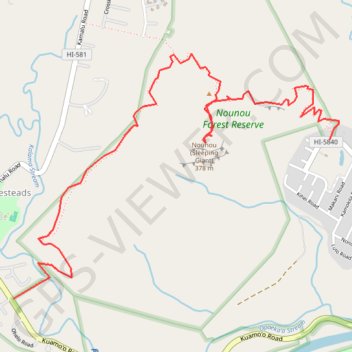
- Distance: 6.2 Km
- Elevation gain: 395 m
- Maximum elevation: 329 m
- Elevation loss: 349 m
- Minimum elevation: 46 m
- Moving time: 2 h 1 m
- Moving speed: 3.0 Km/h
- Maximum speed: 9.5 Km/h
- Total time: 2 h 54 m
- Global speed: 2.1 Km/h
Interactive trail map
Trail profile
- Distance: 6.2 Km
- Elevation gain: 395 m
- Maximum elevation: 329 m
- Elevation loss: 349 m
- Minimum elevation: 46 m
- Moving time: 2 h 1 m
- Moving speed: 3.0 Km/h
- Maximum speed: 9.5 Km/h
- Total time: 2 h 54 m
- Global speed: 2.1 Km/h
About this trail
Name: Sleeping Giant / Nounou (Kauai Island) trail, distance, elevation, map, profile, GPS track
Coordinates: 22.05154 -159.36749 22.06662 -159.34589