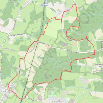
Circuit from Broxbourne Woods
Broxbourne woods
- Distance: 13.6 Km
- Elevation gain: 169 m
- Maximum elevation: 117 m
- Elevation loss: 168 m
- Minimum elevation: 70 m
- Moving time: 2 h 52 m
- Moving speed: 4.7 Km/h
- Maximum speed: 7.7 Km/h
- Total time: 3 h 35 m
- Global speed: 3.8 Km/h
Interactive trail map
Trail profile
- Distance: 13.6 Km
- Elevation gain: 169 m
- Maximum elevation: 117 m
- Elevation loss: 168 m
- Minimum elevation: 70 m
- Moving time: 2 h 52 m
- Moving speed: 4.7 Km/h
- Maximum speed: 7.7 Km/h
- Total time: 3 h 35 m
- Global speed: 3.8 Km/h
About this trail
Name: Circuit from Broxbourne Woods trail, distance, elevation, map, profile, GPS track
Coordinates: 51.72549 -0.11549 51.75769 -0.06825
Other hiking, mountain biking, running and outdoor activity trails
Click on a trail to view its statistics, map and profile.
Hertfordshire Chain Walk 3&4
United Kingdom > England > Hertfordshire > East Hertfordshire > Bayford
Distance: 19.4 Km • Elevation gain: 224 m • Maximum elevation: 129 m