Thank you for supporting this site ❤️
Make a donation
Make a donation
Gear up for your next adventure:
As an Amazon Associate, this site earns from qualifying purchases at no extra cost to you.
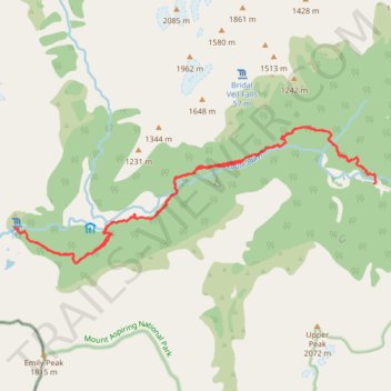
Routeburn Track to Falls Lodge in Mount Aspiring National Park
- Distance: 19.5 Km
- Elevation gain: 1,043 m
- Maximum elevation: 994 m
- Elevation loss: 1,055 m
- Minimum elevation: 471 m
- Moving time: 5 h 21 m
- Moving speed: 3.6 Km/h
- Maximum speed: 9.4 Km/h
- Total time: 6 h 7 m
- Global speed: 3.2 Km/h
Interactive trail map
Thank you for supporting this site ❤️
Make a donation
Make a donation
Gear up for your next adventure:
As an Amazon Associate, this site earns from qualifying purchases at no extra cost to you.
Trail profile
- Distance: 19.5 Km
- Elevation gain: 1,043 m
- Maximum elevation: 994 m
- Elevation loss: 1,055 m
- Minimum elevation: 471 m
- Moving time: 5 h 21 m
- Moving speed: 3.6 Km/h
- Maximum speed: 9.4 Km/h
- Total time: 6 h 7 m
- Global speed: 3.2 Km/h
Thank you for supporting this site ❤️
Make a donation
Make a donation
Gear up for your next adventure:
As an Amazon Associate, this site earns from qualifying purchases at no extra cost to you.
About this trail
Name: Routeburn Track to Falls Lodge in Mount Aspiring National Park trail, distance, elevation, map, profile, GPS track
End: Routeburn Track, Queenstown-Lakes District, New Zealand (-44.71749 168.27826)
Coordinates: -44.73128 168.19858 -44.70997 168.27841
Thank you for supporting this site ❤️
Make a donation
Make a donation
Gear up for your next adventure:
As an Amazon Associate, this site earns from qualifying purchases at no extra cost to you.