Thank you for supporting this site ❤️
Make a donation
Make a donation
Gear up for your next adventure:
As an Amazon Associate, this site earns from qualifying purchases at no extra cost to you.
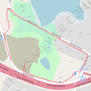
Loop walk in Savory Park via Strachan Trail along Florence Lake
- Distance: 1.3 Km
- Elevation gain: 20 m
- Maximum elevation: 92 m
- Elevation loss: 22 m
- Minimum elevation: 78 m
- Moving time: 23 m 8 s
- Moving speed: 3.4 Km/h
- Maximum speed: 7.7 Km/h
- Total time: 26 m 3 s
- Global speed: 3.0 Km/h
Interactive trail map
Thank you for supporting this site ❤️
Make a donation
Make a donation
Gear up for your next adventure:
As an Amazon Associate, this site earns from qualifying purchases at no extra cost to you.
Trail profile
- Distance: 1.3 Km
- Elevation gain: 20 m
- Maximum elevation: 92 m
- Elevation loss: 22 m
- Minimum elevation: 78 m
- Moving time: 23 m 8 s
- Moving speed: 3.4 Km/h
- Maximum speed: 7.7 Km/h
- Total time: 26 m 3 s
- Global speed: 3.0 Km/h
Thank you for supporting this site ❤️
Make a donation
Make a donation
Gear up for your next adventure:
As an Amazon Associate, this site earns from qualifying purchases at no extra cost to you.
About this trail
Name: Loop walk in Savory Park via Strachan Trail along Florence Lake trail, distance, elevation, map, profile, GPS track
Coordinates: 48.45316 -123.51543 48.45676 -123.50931
Topography: Langford topographic map, elevation, terrain
Thank you for supporting this site ❤️
Make a donation
Make a donation
Gear up for your next adventure:
As an Amazon Associate, this site earns from qualifying purchases at no extra cost to you.