Make a donation
Gear up for your next adventure:
As an Amazon Associate, this site earns from qualifying purchases at no extra cost to you.
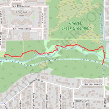
Chester Creek
- Distance: 1.1 Km
- Elevation gain: 8 m
- Maximum elevation: 26 m
- Elevation loss: 1 m
- Minimum elevation: 18 m
- Moving time: 18 m 3 s
- Moving speed: 3.8 Km/h
- Maximum speed: 7.2 Km/h
- Total time: 18 m 37 s
- Global speed: 3.7 Km/h
Interactive trail map
Make a donation
Gear up for your next adventure:
As an Amazon Associate, this site earns from qualifying purchases at no extra cost to you.
Trail profile
- Distance: 1.1 Km
- Elevation gain: 8 m
- Maximum elevation: 26 m
- Elevation loss: 1 m
- Minimum elevation: 18 m
- Moving time: 18 m 3 s
- Moving speed: 3.8 Km/h
- Maximum speed: 7.2 Km/h
- Total time: 18 m 37 s
- Global speed: 3.7 Km/h
Make a donation
Gear up for your next adventure:
As an Amazon Associate, this site earns from qualifying purchases at no extra cost to you.
About this trail
Name: Chester Creek trail, distance, elevation, map, profile, GPS track
Start: Chester Creek Trail, Rogers Park, Anchorage, Alaska, 88591, United States (61.20126 -149.86101)
Coordinates: 61.20071 -149.86101 61.20220 -149.84553
Make a donation
Gear up for your next adventure:
As an Amazon Associate, this site earns from qualifying purchases at no extra cost to you.
Other hiking, mountain biking, running and outdoor activity trails
Click on a trail to view its statistics, map and profile.
Road Trip Alaska 2018
United States > Alaska > Anchorage
From Anchorage.
Distance: 641.7 Km • Elevation gain: 4,791 m • Maximum elevation: 739 m