Thank you for supporting this site ❤️
Make a donation
Make a donation
Gear up for your next adventure:
As an Amazon Associate, this site earns from qualifying purchases at no extra cost to you.
Panguil Bay Bridge
- Distance: 9.4 Km
- Elevation gain: 25 m
- Maximum elevation: 9 m
- Elevation loss: 26 m
- Minimum elevation: 0 m
- Moving time: 35 m 55 s
- Moving speed: 15.8 Km/h
- Maximum speed: 38.9 Km/h
- Total time: 35 m 55 s
- Global speed: 15.8 Km/h
Interactive trail map
Thank you for supporting this site ❤️
Make a donation
Make a donation
Gear up for your next adventure:
As an Amazon Associate, this site earns from qualifying purchases at no extra cost to you.
Trail profile
- Distance: 9.4 Km
- Elevation gain: 25 m
- Maximum elevation: 9 m
- Elevation loss: 26 m
- Minimum elevation: 0 m
- Moving time: 35 m 55 s
- Moving speed: 15.8 Km/h
- Maximum speed: 38.9 Km/h
- Total time: 35 m 55 s
- Global speed: 15.8 Km/h
Thank you for supporting this site ❤️
Make a donation
Make a donation
Gear up for your next adventure:
As an Amazon Associate, this site earns from qualifying purchases at no extra cost to you.
About this trail
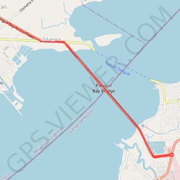
Name: Panguil Bay Bridge trail, distance, elevation, map, profile, GPS track
Coordinates: 8.04209 123.75635 8.07035 123.79149
Thank you for supporting this site ❤️
Make a donation
Make a donation
Gear up for your next adventure:
As an Amazon Associate, this site earns from qualifying purchases at no extra cost to you.