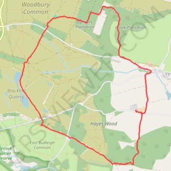
Woodbury Common
- Distance: 7.8 Km
- Elevation gain: 148 m
- Maximum elevation: 132 m
- Elevation loss: 148 m
- Minimum elevation: 42 m
- Moving time: 2 h 15 m
- Moving speed: 3.4 Km/h
- Maximum speed: 6.0 Km/h
- Total time: 2 h 32 m
- Global speed: 3.0 Km/h
Interactive trail map
Trail profile
- Distance: 7.8 Km
- Elevation gain: 148 m
- Maximum elevation: 132 m
- Elevation loss: 148 m
- Minimum elevation: 42 m
- Moving time: 2 h 15 m
- Moving speed: 3.4 Km/h
- Maximum speed: 6.0 Km/h
- Total time: 2 h 32 m
- Global speed: 3.0 Km/h
About this trail
Name: Woodbury Common trail, distance, elevation, map, profile, GPS track
End: B3180, Woodbury, East Devon, Devon, England, EX5 1JL, United Kingdom (50.66932 -3.36305)
Coordinates: 50.65093 -3.36878 50.67183 -3.34143