Import a GPX file

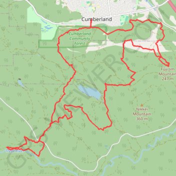
Cumberland - Allen Lake - Trent River

Vancouver Island. #Hiking #MTB #Loop #Vancouver

  • Distance: 24.8 Km
  • Elevation gain: 675 m
  • Maximum elevation: 527 m
  • Elevation loss: 675 m
  • Minimum elevation: 136 m

Interactive trail map

Trail profile

  • Distance: 24.8 Km
  • Elevation gain: 675 m
  • Maximum elevation: 527 m
  • Elevation loss: 675 m
  • Minimum elevation: 136 m

About this trail

Other hiking, mountain biking, running and outdoor activity trails

Click on a trail to view its statistics, map and profile.

Deep Bay - Port Alberni - Cumberland

Canada > British Columbia > Regional District of Nanaimo > Area H (Lighthouse Country)

Vancouver Island. #Bike #Loop #Vancouver

Distance: 149.7 Km • Elevation gain: 3,366 m • Maximum elevation: 465 m

Fanny Bay - Campbell River

Canada > British Columbia > Comox Valley Regional District > Area A (Baynes Sound)

Vancouver Island. #Bike #Fanny #Campbell #Vancouver

Distance: 79.1 Km • Elevation gain: 452 m • Maximum elevation: 93 m

The Cumby Race Course

Canada > British Columbia > Comox Valley Regional District > Cumberland

#Running #Loop #Cumby

Distance: 20.7 Km • Elevation gain: 615 m • Maximum elevation: 420 m

Gear up for your next adventure:

🔭Compact Binoculars - Lightweight optics for scouting trails and wildlife
💧Hydration Bladder - Hands-free hydration solution for long treks
🥾Trail Running Shoes - Lightweight and durable shoes for trail running
💡Compact LED Flashlight - Powerful and portable flashlight for outdoor use
🪑Ultralight Camping Stool - Compact seating for rest stops during long hikes

As an Amazon Associate, this site earns from qualifying purchases at no extra cost to you.