Make a donation
Gear up for your next adventure:
As an Amazon Associate, this site earns from qualifying purchases at no extra cost to you.
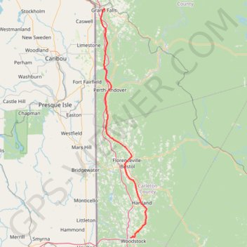
Grand Falls - Woodstock
- Distance: 118.5 Km
- Elevation gain: 915 m
- Maximum elevation: 222 m
- Elevation loss: 967 m
- Minimum elevation: 39 m
Interactive trail map
Make a donation
Gear up for your next adventure:
As an Amazon Associate, this site earns from qualifying purchases at no extra cost to you.
Trail profile
- Distance: 118.5 Km
- Elevation gain: 915 m
- Maximum elevation: 222 m
- Elevation loss: 967 m
- Minimum elevation: 39 m
Make a donation
Gear up for your next adventure:
As an Amazon Associate, this site earns from qualifying purchases at no extra cost to you.
About this trail
Name: Grand Falls - Woodstock trail, distance, elevation, map, profile, GPS track
Coordinates: 46.16276 -67.75792 47.04918 -67.49733
Topography: Victoria County topographic map, elevation, terrain
Make a donation
Gear up for your next adventure:
As an Amazon Associate, this site earns from qualifying purchases at no extra cost to you.
Other hiking, mountain biking, running and outdoor activity trails
Click on a trail to view its statistics, map and profile.
Woodstock - Upper Kingsclear
Canada > New Brunswick > Woodstock Parish > Woodstock
Saint John River. #Bike #Woodstock #UpperKingsclear #SaintJohn
Distance: 77.2 Km • Elevation gain: 588 m • Maximum elevation: 100 m
Edmundston - Grand Falls
Canada > New Brunswick > Saint-Jacques Parish > Edmundston
Distance: 72.0 Km • Elevation gain: 347 m • Maximum elevation: 172 m