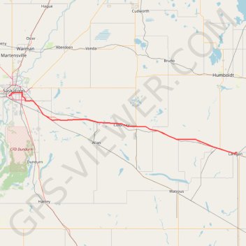
Saskatoon - Lanigan
Interactive trail map
Trail profile
- Distance: 129.5 Km
- Elevation gain: 236 m
- Maximum elevation: 559 m
- Elevation loss: 188 m
- Minimum elevation: 474 m
About this trail
Name: Saskatoon - Lanigan trail, distance, elevation, map, profile, GPS track
Start: 16, Embassy Drive, Holiday Park, Saskatoon, Saskatchewan, S7M 2M6, Canada (52.10621 -106.69206)
End: Downing Drive, Lanigan, Saskatchewan, S0K 2M0, Canada (51.85079 -105.02115)
Coordinates: 51.84530 -106.69410 52.12304 -105.02115
Topography: Saskatoon topographic map, elevation, terrain
Other hiking, mountain biking, running and outdoor activity trails
Click on a trail to view its statistics, map and profile.