Make a donation
Gear up for your next adventure:
As an Amazon Associate, this site earns from qualifying purchases at no extra cost to you.
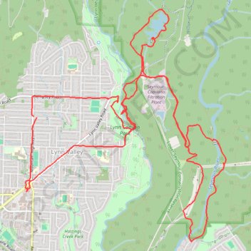
Lynn Valley - Rice Lake
Interactive trail map
Make a donation
Gear up for your next adventure:
As an Amazon Associate, this site earns from qualifying purchases at no extra cost to you.
Trail profile
- Distance: 19.8 Km
- Elevation gain: 658 m
- Maximum elevation: 232 m
- Elevation loss: 660 m
- Minimum elevation: 70 m
Make a donation
Gear up for your next adventure:
As an Amazon Associate, this site earns from qualifying purchases at no extra cost to you.
About this trail
Name: Lynn Valley - Rice Lake trail, distance, elevation, map, profile, GPS track
Coordinates: 49.32940 -123.03930 49.35911 -122.99994
Topography: Metro Vancouver Regional District topographic map, elevation, terrain
Make a donation
Gear up for your next adventure:
As an Amazon Associate, this site earns from qualifying purchases at no extra cost to you.
Other hiking, mountain biking, running and outdoor activity trails
Click on a trail to view its statistics, map and profile.
Cedar Tree Trail - Kennedy Falls
Canada > British Columbia > Metro Vancouver Regional District
Lynn Headwaters Regional Park. #Hiking #LynnHeadwaters #Kennedy
Distance: 5.5 Km • Elevation gain: 319 m • Maximum elevation: 473 m
Make a donation
Gear up for your next adventure:
As an Amazon Associate, this site earns from qualifying purchases at no extra cost to you.
Lynn Peak route fast hike / run
Canada > British Columbia > Metro Vancouver Regional District > Electoral Area A
Distance: 10.0 Km • Elevation gain: 752 m • Maximum elevation: 936 m