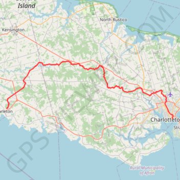
Borden-Carleton - Charlottetown
Prince Edward Island. #Bike #BordenCarleton #Charlottetown #PrinceEdward
- Distance: 65.2 Km
- Elevation gain: 364 m
- Maximum elevation: 94 m
- Elevation loss: 369 m
- Minimum elevation: 1 m
Interactive trail map
Trail profile
- Distance: 65.2 Km
- Elevation gain: 364 m
- Maximum elevation: 94 m
- Elevation loss: 369 m
- Minimum elevation: 1 m
About this trail
Name: Borden-Carleton - Charlottetown trail, distance, elevation, map, profile, GPS track
Coordinates: 46.23628 -63.65833 46.36491 -63.11883
Topography: Town of Borden-Carleton topographic map, elevation, terrain
Other hiking, mountain biking, running and outdoor activity trails
Click on a trail to view its statistics, map and profile.
Charlottetown to Stratford on bicycle
Canada > Prince Edward Island > Queens County > Charlottetown
Distance: 9.6 Km • Elevation gain: 51 m • Maximum elevation: 23 m
Borden-Charleton - Charlottetown
Canada > Prince Edward Island > Town of Borden-Carleton > Cape Traverse
Prince Edward Island. #Bike #BordenCharleton #Charlottetown
Distance: 59.7 Km • Elevation gain: 386 m • Maximum elevation: 39 m
Breadalbane Nature Loop Trail
Canada > Prince Edward Island > Queens County > Breadalbane
Distance: 6.6 Km • Elevation gain: 52 m • Maximum elevation: 52 m