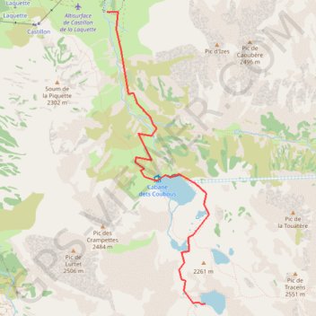
Day 6 Dets Coubous Valley
- Distance: 5.6 Km
- Elevation gain: 690 m
- Maximum elevation: 2,230 m
- Elevation loss: 6 m
- Minimum elevation: 1,544 m
- Moving time: 1 h 12 m
- Moving speed: 4.7 Km/h
- Maximum speed: 8.3 Km/h
- Total time: 1 h 12 m
- Global speed: 4.7 Km/h
Interactive trail map
Trail profile
- Distance: 5.6 Km
- Elevation gain: 690 m
- Maximum elevation: 2,230 m
- Elevation loss: 6 m
- Minimum elevation: 1,544 m
- Moving time: 1 h 12 m
- Moving speed: 4.7 Km/h
- Maximum speed: 8.3 Km/h
- Total time: 1 h 12 m
- Global speed: 4.7 Km/h
About this trail
Name: Day 6 Dets Coubous Valley trail, distance, elevation, map, profile, GPS track
Coordinates: 42.86347 0.10521 42.89536 0.12040
Other hiking, mountain biking, running and outdoor activity trails
Click on a trail to view its statistics, map and profile.
Southern section — European Divide Trail
France > Auvergne-Rhône-Alpes > Drôme > Valence
Distance: 2,423.8 Km • Elevation gain: 42,375 m • Maximum elevation: 2,005 m
GR 10 - Traversée des Pyrénées
France > Occitania > Pyrénées-Orientales > Banyuls-sur-Mer
Distance: 874.8 Km • Elevation gain: 57,000 m • Maximum elevation: 2,599 m
1 LUCENA - MONTPELLIER
Distance: 2,964.4 Km • Elevation gain: 29,500 m • Maximum elevation: 1,048 m