Thank you for supporting this site ❤️
Make a donation
Make a donation
Gear up for your next adventure:
As an Amazon Associate, this site earns from qualifying purchases at no extra cost to you.
Tracked with OSMTracker for Android™
407
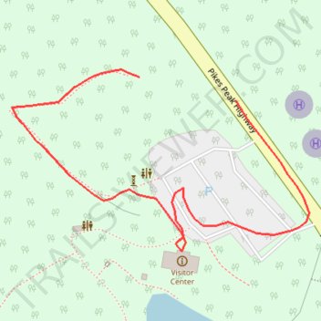
- Distance: 0.5 Km
- Elevation gain: 9 m
- Maximum elevation: 2,833 m
- Elevation loss: 16 m
- Minimum elevation: 2,816 m
- Moving time: 5 m
- Moving speed: 5.6 Km/h
- Maximum speed: 45.9 Km/h
- Total time: 8 m 45 s
- Global speed: 3.2 Km/h
Interactive trail map
Thank you for supporting this site ❤️
Make a donation
Make a donation
Gear up for your next adventure:
As an Amazon Associate, this site earns from qualifying purchases at no extra cost to you.
Trail profile
- Distance: 0.5 Km
- Elevation gain: 9 m
- Maximum elevation: 2,833 m
- Elevation loss: 16 m
- Minimum elevation: 2,816 m
- Moving time: 5 m
- Moving speed: 5.6 Km/h
- Maximum speed: 45.9 Km/h
- Total time: 8 m 45 s
- Global speed: 3.2 Km/h
Thank you for supporting this site ❤️
Make a donation
Make a donation
Gear up for your next adventure:
As an Amazon Associate, this site earns from qualifying purchases at no extra cost to you.
About this trail
Name: Tracked with OSMTracker for Android™ trail, distance, elevation, map, profile, GPS track
Start: Pikes Peak Highway, El Paso County, Colorado, 80819, United States (38.92202 -105.02619)
End: Pikes Peak Highway, El Paso County, Colorado, 80819, United States (38.92189 -105.02551)
Coordinates: 38.92106 -105.02709 38.92206 -105.02499
Thank you for supporting this site ❤️
Make a donation
Make a donation
Gear up for your next adventure:
As an Amazon Associate, this site earns from qualifying purchases at no extra cost to you.