Thank you for supporting this site ❤️
Make a donation
Make a donation
Gear up for your next adventure:
As an Amazon Associate, this site earns from qualifying purchases at no extra cost to you.
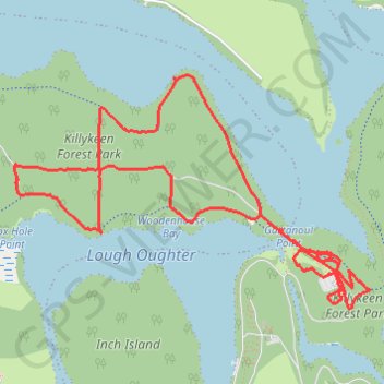
Killykeen Forest Park
Loop hike through Killykeen Forest by the Lough Oughter from Derinish Beg via Killykeen Greenway. #Hiking #Loop #Nature #Forest #Park #Lake
- Distance: 7.5 Km
- Elevation gain: 95 m
- Maximum elevation: 68 m
- Elevation loss: 93 m
- Minimum elevation: 46 m
- Moving time: 1 h 30 m
- Moving speed: 4.9 Km/h
- Maximum speed: 13.2 Km/h
- Total time: 1 h 33 m
- Global speed: 4.8 Km/h
Interactive trail map
Thank you for supporting this site ❤️
Make a donation
Make a donation
Gear up for your next adventure:
As an Amazon Associate, this site earns from qualifying purchases at no extra cost to you.
Trail profile
- Distance: 7.5 Km
- Elevation gain: 95 m
- Maximum elevation: 68 m
- Elevation loss: 93 m
- Minimum elevation: 46 m
- Moving time: 1 h 30 m
- Moving speed: 4.9 Km/h
- Maximum speed: 13.2 Km/h
- Total time: 1 h 33 m
- Global speed: 4.8 Km/h
Thank you for supporting this site ❤️
Make a donation
Make a donation
Gear up for your next adventure:
As an Amazon Associate, this site earns from qualifying purchases at no extra cost to you.
About this trail
Name: Killykeen Forest Park trail, distance, elevation, map, profile, GPS track
Coordinates: 54.00448 -7.49225 54.01533 -7.46404
Thank you for supporting this site ❤️
Make a donation
Make a donation
Gear up for your next adventure:
As an Amazon Associate, this site earns from qualifying purchases at no extra cost to you.