Make a donation
Gear up for your next adventure:
As an Amazon Associate, this site earns from qualifying purchases at no extra cost to you.
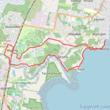
Tuggerawong Pathway from Wyong
- Distance: 19.0 Km
- Elevation gain: 119 m
- Maximum elevation: 29 m
- Elevation loss: 120 m
- Minimum elevation: 0 m
- Moving time: 2 h 11 m
- Moving speed: 8.7 Km/h
- Maximum speed: 17.5 Km/h
- Total time: 2 h 26 m
- Global speed: 7.8 Km/h
Interactive trail map
Make a donation
Gear up for your next adventure:
As an Amazon Associate, this site earns from qualifying purchases at no extra cost to you.
Trail profile
- Distance: 19.0 Km
- Elevation gain: 119 m
- Maximum elevation: 29 m
- Elevation loss: 120 m
- Minimum elevation: 0 m
- Moving time: 2 h 11 m
- Moving speed: 8.7 Km/h
- Maximum speed: 17.5 Km/h
- Total time: 2 h 26 m
- Global speed: 7.8 Km/h
Make a donation
Gear up for your next adventure:
As an Amazon Associate, this site earns from qualifying purchases at no extra cost to you.
About this trail
Name: Tuggerawong Pathway from Wyong trail, distance, elevation, map, profile, GPS track
Start: 23, North Road, Wyong, Central Coast Council, New South Wales, 2259, Australia (-33.27923 151.42295)
End: 23, North Road, Wyong, New South Wales, 2259, Australia (-33.27933 151.42296)
Coordinates: -33.29464 151.42017 -33.27590 151.48909
Make a donation
Gear up for your next adventure:
As an Amazon Associate, this site earns from qualifying purchases at no extra cost to you.
Other hiking, mountain biking, running and outdoor activity trails
Click on a trail to view its statistics, map and profile.
Pioneer Dairy parkrun
Distance: 5.2 Km • Elevation gain: 12 m • Maximum elevation: 6 m