Make a donation
Gear up for your next adventure:
As an Amazon Associate, this site earns from qualifying purchases at no extra cost to you.
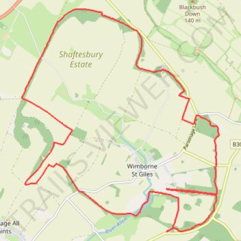
Wimbourne St Giles half marathon
Wimborne St Giles as lovely as ever. Really nice sunny day, bit of breeze but mostly dappled shade anyway. Good fueling with 3-4 jelly babies every 5km. Great route.
- Distance: 21.3 Km
- Elevation gain: 253 m
- Maximum elevation: 109 m
- Elevation loss: 253 m
- Minimum elevation: 47 m
- Moving time: 1 h 57 m
- Moving speed: 10.8 Km/h
- Maximum speed: 16.2 Km/h
- Total time: 1 h 57 m
- Global speed: 10.8 Km/h
Interactive trail map
Make a donation
Gear up for your next adventure:
As an Amazon Associate, this site earns from qualifying purchases at no extra cost to you.
Trail profile
- Distance: 21.3 Km
- Elevation gain: 253 m
- Maximum elevation: 109 m
- Elevation loss: 253 m
- Minimum elevation: 47 m
- Moving time: 1 h 57 m
- Moving speed: 10.8 Km/h
- Maximum speed: 16.2 Km/h
- Total time: 1 h 57 m
- Global speed: 10.8 Km/h
Make a donation
Gear up for your next adventure:
As an Amazon Associate, this site earns from qualifying purchases at no extra cost to you.
About this trail
Name: Wimbourne St Giles half marathon trail, distance, elevation, map, profile, GPS track
Start: Wimborne St. Giles, Wimborne St Giles, Dorset, England, BH21 5NB, United Kingdom (50.90367 -1.95260)
End: Wimborne St. Giles, Wimborne St Giles, Dorset, England, BH21 5NB, United Kingdom (50.90360 -1.95243)
Coordinates: 50.89530 -1.99703 50.93865 -1.93631
Make a donation
Gear up for your next adventure:
As an Amazon Associate, this site earns from qualifying purchases at no extra cost to you.