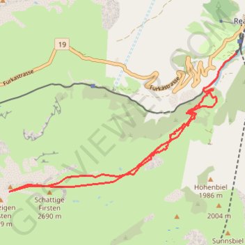
60576
- Distance: 13.6 Km
- Elevation gain: 1,191 m
- Maximum elevation: 2,733 m
- Elevation loss: 1,191 m
- Minimum elevation: 1,556 m
Interactive trail map
Trail profile
- Distance: 13.6 Km
- Elevation gain: 1,191 m
- Maximum elevation: 2,733 m
- Elevation loss: 1,191 m
- Minimum elevation: 1,556 m
About this trail
Name: 60576 trail, distance, elevation, map, profile, GPS track
Start: 17, Schweigstrasse, Realp, Korporation Ursern, Uri, 6491, Switzerland (46.59295 8.50000)
End: 17, Schweigstrasse, Realp, Korporation Ursern, Uri, 6491, Switzerland (46.59318 8.50013)
Coordinates: 46.56949 8.44363 46.59318 8.50015
Other hiking, mountain biking, running and outdoor activity trails
Click on a trail to view its statistics, map and profile.
Ticino: snowy mountain passes, palm-lined riviera, and epic roadsTrack
Switzerland > Uri > Korporation Ursern > Hospental
Distance: 376.9 Km • Elevation gain: 9,792 m • Maximum elevation: 2,581 m