Thank you for supporting this site ❤️
Make a donation
Make a donation
Gear up for your next adventure:
As an Amazon Associate, this site earns from qualifying purchases at no extra cost to you.
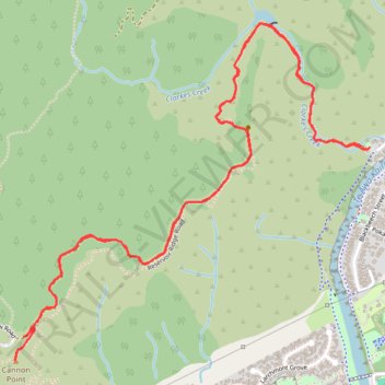
2024-10-06_11-08_Sun
- Distance: 7.6 Km
- Elevation gain: 295 m
- Maximum elevation: 332 m
- Elevation loss: 297 m
- Minimum elevation: 94 m
- Moving time: 1 h 43 m
- Moving speed: 4.4 Km/h
- Maximum speed: 7.9 Km/h
- Total time: 2 h 5 m
- Global speed: 3.6 Km/h
Interactive trail map
Thank you for supporting this site ❤️
Make a donation
Make a donation
Gear up for your next adventure:
As an Amazon Associate, this site earns from qualifying purchases at no extra cost to you.
Trail profile
- Distance: 7.6 Km
- Elevation gain: 295 m
- Maximum elevation: 332 m
- Elevation loss: 297 m
- Minimum elevation: 94 m
- Moving time: 1 h 43 m
- Moving speed: 4.4 Km/h
- Maximum speed: 7.9 Km/h
- Total time: 2 h 5 m
- Global speed: 3.6 Km/h
Thank you for supporting this site ❤️
Make a donation
Make a donation
Gear up for your next adventure:
As an Amazon Associate, this site earns from qualifying purchases at no extra cost to you.
About this trail
Name: 2024-10-06_11-08_Sun trail, distance, elevation, map, profile, GPS track
Coordinates: -41.10342 175.07288 -41.08951 175.09231
Thank you for supporting this site ❤️
Make a donation
Make a donation
Gear up for your next adventure:
As an Amazon Associate, this site earns from qualifying purchases at no extra cost to you.