Thank you for supporting this site ❤️
Make a donation
Make a donation
Gear up for your next adventure:
As an Amazon Associate, this site earns from qualifying purchases at no extra cost to you.
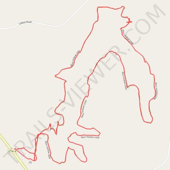
Bass Hollow Loop
- Distance: 6.3 Km
- Elevation gain: 166 m
- Maximum elevation: 390 m
- Elevation loss: 166 m
- Minimum elevation: 317 m
- Moving time: 1 h 17 m
- Moving speed: 4.8 Km/h
- Maximum speed: 23.8 Km/h
- Total time: 1 h 25 m
- Global speed: 4.4 Km/h
Interactive trail map
Thank you for supporting this site ❤️
Make a donation
Make a donation
Gear up for your next adventure:
As an Amazon Associate, this site earns from qualifying purchases at no extra cost to you.
Trail profile
- Distance: 6.3 Km
- Elevation gain: 166 m
- Maximum elevation: 390 m
- Elevation loss: 166 m
- Minimum elevation: 317 m
- Moving time: 1 h 17 m
- Moving speed: 4.8 Km/h
- Maximum speed: 23.8 Km/h
- Total time: 1 h 25 m
- Global speed: 4.4 Km/h
Thank you for supporting this site ❤️
Make a donation
Make a donation
Gear up for your next adventure:
As an Amazon Associate, this site earns from qualifying purchases at no extra cost to you.
About this trail
Name: Bass Hollow Loop trail, distance, elevation, map, profile, GPS track
Start: Town of Seven Mile Creek, Juneau County, Wisconsin, United States (43.67240 -90.03231)
End: Town of Seven Mile Creek, Juneau County, Wisconsin, United States (43.67250 -90.03239)
Coordinates: 43.67152 -90.03250 43.68145 -90.02018
Thank you for supporting this site ❤️
Make a donation
Make a donation
Gear up for your next adventure:
As an Amazon Associate, this site earns from qualifying purchases at no extra cost to you.