Thank you for supporting this site ❤️
Make a donation
Make a donation
Gear up for your next adventure:
As an Amazon Associate, this site earns from qualifying purchases at no extra cost to you.
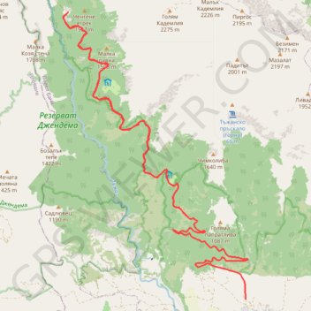
Kademliisko praskalo
- Distance: 28.7 Km
- Elevation gain: 1,715 m
- Maximum elevation: 1,402 m
- Elevation loss: 1,285 m
- Minimum elevation: 586 m
- Moving time: 5 h 32 m
- Moving speed: 5.2 Km/h
- Maximum speed: 18.4 Km/h
- Total time: 6 h 29 m
- Global speed: 4.4 Km/h
Interactive trail map
Thank you for supporting this site ❤️
Make a donation
Make a donation
Gear up for your next adventure:
As an Amazon Associate, this site earns from qualifying purchases at no extra cost to you.
Trail profile
- Distance: 28.7 Km
- Elevation gain: 1,715 m
- Maximum elevation: 1,402 m
- Elevation loss: 1,285 m
- Minimum elevation: 586 m
- Moving time: 5 h 32 m
- Moving speed: 5.2 Km/h
- Maximum speed: 18.4 Km/h
- Total time: 6 h 29 m
- Global speed: 4.4 Km/h
Thank you for supporting this site ❤️
Make a donation
Make a donation
Gear up for your next adventure:
As an Amazon Associate, this site earns from qualifying purchases at no extra cost to you.
About this trail
Name: Kademliisko praskalo trail, distance, elevation, map, profile, GPS track
End: с. Тъжа - х. Тъжа, Tazha, Pavel Bania, Stara Zagora, 6160, Bulgaria (42.67992 25.06196)
Coordinates: 42.66060 25.02286 42.72740 25.08134
Thank you for supporting this site ❤️
Make a donation
Make a donation
Gear up for your next adventure:
As an Amazon Associate, this site earns from qualifying purchases at no extra cost to you.