Thank you for supporting this site ❤️
Make a donation
Make a donation
Gear up for your next adventure:
As an Amazon Associate, this site earns from qualifying purchases at no extra cost to you.
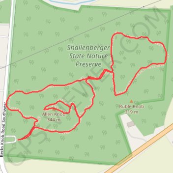
Shallenberger Park Trails
- Distance: 2.6 Km
- Elevation gain: 89 m
- Maximum elevation: 335 m
- Elevation loss: 88 m
- Minimum elevation: 284 m
- Moving time: 29 m 58 s
- Moving speed: 5.2 Km/h
- Maximum speed: 13.4 Km/h
- Total time: 29 m 58 s
- Global speed: 5.2 Km/h
Interactive trail map
Thank you for supporting this site ❤️
Make a donation
Make a donation
Gear up for your next adventure:
As an Amazon Associate, this site earns from qualifying purchases at no extra cost to you.
Trail profile
- Distance: 2.6 Km
- Elevation gain: 89 m
- Maximum elevation: 335 m
- Elevation loss: 88 m
- Minimum elevation: 284 m
- Moving time: 29 m 58 s
- Moving speed: 5.2 Km/h
- Maximum speed: 13.4 Km/h
- Total time: 29 m 58 s
- Global speed: 5.2 Km/h
Thank you for supporting this site ❤️
Make a donation
Make a donation
Gear up for your next adventure:
As an Amazon Associate, this site earns from qualifying purchases at no extra cost to you.
About this trail
Name: Shallenberger Park Trails trail, distance, elevation, map, profile, GPS track
Coordinates: 39.69146 -82.65763 39.69528 -82.65021
Thank you for supporting this site ❤️
Make a donation
Make a donation
Gear up for your next adventure:
As an Amazon Associate, this site earns from qualifying purchases at no extra cost to you.