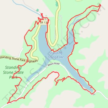
Standing Stone State Park - Lake Trail loop hike
- Distance: 8.4 Km
- Elevation gain: 303 m
- Maximum elevation: 292 m
- Elevation loss: 303 m
- Minimum elevation: 211 m
- Moving time: 2 h 34 m
- Moving speed: 3.2 Km/h
- Maximum speed: 16.0 Km/h
- Total time: 3 h 20 m
- Global speed: 2.5 Km/h
Interactive trail map
Trail profile
- Distance: 8.4 Km
- Elevation gain: 303 m
- Maximum elevation: 292 m
- Elevation loss: 303 m
- Minimum elevation: 211 m
- Moving time: 2 h 34 m
- Moving speed: 3.2 Km/h
- Maximum speed: 16.0 Km/h
- Total time: 3 h 20 m
- Global speed: 2.5 Km/h
About this trail
Name: Standing Stone State Park - Lake Trail loop hike trail, distance, elevation, map, profile, GPS track
Coordinates: 36.46047 -85.42370 36.47291 -85.40923