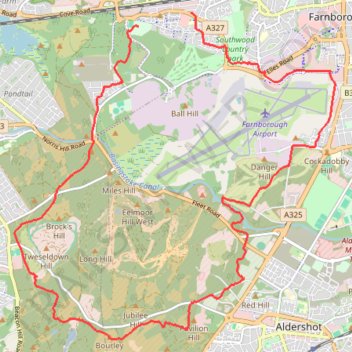
Caesar's Bypass Cycle Route
- Distance: 18.5 Km
- Elevation gain: 157 m
- Maximum elevation: 141 m
- Elevation loss: 153 m
- Minimum elevation: 64 m
- Moving time: 1 h 32 m
- Moving speed: 12.0 Km/h
- Maximum speed: 34.5 Km/h
- Total time: 1 h 53 m
- Global speed: 9.8 Km/h
Interactive trail map
Trail profile
- Distance: 18.5 Km
- Elevation gain: 157 m
- Maximum elevation: 141 m
- Elevation loss: 153 m
- Minimum elevation: 64 m
- Moving time: 1 h 32 m
- Moving speed: 12.0 Km/h
- Maximum speed: 34.5 Km/h
- Total time: 1 h 53 m
- Global speed: 9.8 Km/h
About this trail
Name: Caesar's Bypass Cycle Route trail, distance, elevation, map, profile, GPS track
Coordinates: 51.24764 -0.82505 51.29228 -0.75450
Other hiking, mountain biking, running and outdoor activity trails
Click on a trail to view its statistics, map and profile.
Brighton Hill - South Downs National Park
United Kingdom > England > Hampshire > Basingstoke and Deane > Basingstoke
MTB loop from Brighton Hill to South Downs National Park via Upton Grey, Long Sutton, Farnham, Tilford, Holt Pound, Lodge Inclosure, Bentley, Lower Froyle and South Warnborough. #MTB #Loop #Nature #Countryside #Forest
Distance: 68.2 Km • Elevation gain: 914 m • Maximum elevation: 183 m