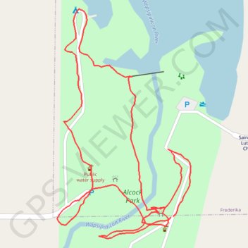
Alcock Park Loop
- Distance: 2.0 Km
- Elevation gain: 9 m
- Maximum elevation: 316 m
- Elevation loss: 9 m
- Minimum elevation: 310 m
- Moving time: 32 m 19 s
- Moving speed: 3.6 Km/h
- Maximum speed: 10.2 Km/h
- Total time: 39 m 53 s
- Global speed: 2.9 Km/h
Interactive trail map
Trail profile
- Distance: 2.0 Km
- Elevation gain: 9 m
- Maximum elevation: 316 m
- Elevation loss: 9 m
- Minimum elevation: 310 m
- Moving time: 32 m 19 s
- Moving speed: 3.6 Km/h
- Maximum speed: 10.2 Km/h
- Total time: 39 m 53 s
- Global speed: 2.9 Km/h
About this trail
Name: Alcock Park Loop trail, distance, elevation, map, profile, GPS track
Start: Swinging Bridge, Frederika, Bremer County, Iowa, 50631, United States (42.88017 -92.31017)
End: Swinging Bridge, Frederika, Bremer County, Iowa, 50631, United States (42.88018 -92.31012)
Coordinates: 42.87981 -92.31279 42.88368 -92.30972